


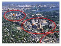
Arlington, Virginia Blood Testing Facilities
 Represents a LabCorp blood testing facility
 Represents a Quest Diagnostics blood testing facility

Nearby Labcorp Blood Testing facilities:
- Labcorp Center Distance: 1 m, 1005 N Glebe Rd Ste 140, Arlington, Arlington County, VA, 22201
- Labcorp Center Distance: 2 m, 1133 21St St Nw Bldg 2, Washington, Other, DC, 20036
- Labcorp Center Distance: 3 m, 1145 19Th St Nw Ste 601, Washington, Other, DC, 20036
- Labcorp Center Distance: 4 m, 5530 Wisconsin Ave Ste 835, Chevy Chase, Montgomery County, MD, 20815
- Labcorp Center Distance: 5 m, 106 Irving Street Nw Ste 1506, Washington, Other, DC, 20010
- Labcorp Center Distance: 6 m, 5130 Duke St Ste 10, Alexandria, Other, VA, 22304
- Labcorp Center Distance: 7 m, 1328 Southern Ave Se Ste 207, Washington, Other, DC, 20032
- Labcorp Center Distance: 8 m, 3311 Toledo Terrace Ste B101, Hyattsville, Prince George's County, MD, 20782
- Labcorp Center Distance: 9 m, 6188 Oxon Hill Rd Ste 104, Oxon Hill, Prince George's County, MD, 20745
- Labcorp Center Distance: 10 m, 6510 Kenilworth Ave. Ste 1500, Riverdale, Prince George's County, MD, 20737
- Labcorp Center Distance: 11 m, 11120 New Hampshire Ave Ste 306, Silver Spring, Montgomery County, MD, 20904
- Labcorp Center Distance: 12 m, 6201 Greenbelt Rd Ste U1, College Park, Prince George's County, MD, 20740
- Labcorp Center Distance: 13 m, 7525 Greenway Center Dr Ste 104, Greenbelt, Prince George's County, MD, 20770
- Labcorp Center Distance: 14 m, 9131 Piscataway Rd Ste 130, Clinton, Prince George's County, MD, 20735
- Labcorp Center Distance: 15 m, 9560 Pennsylvania Ave. Ste 203, Upper Marlboro, Prince George's County, MD, 20772
- Labcorp Center Distance: 16 m, 12200 Annapolis Rd Suite 120, Glenn Dale, Prince George's County, MD, 20769
- Labcorp Center Distance: 17 m, 7350 Van Dusen Rd Ste B, Laurel, Prince George's County, MD, 20707
- Labcorp Center Distance: 18 m, 21475 Ridgetop Cir Ste 110, Dulles, Loudoun County, VA, 20166
- Labcorp Center Distance: 20 m, 14010 Smoketown Road Ste 101, Woodbridge, Prince William County, VA, 22192
- Labcorp Center Distance: 21 m, 19785 Crystal Rock Dr Ste 308, Germantown, Montgomery County, MD, 20874
- Labcorp Center Distance: 22 m, 8609 Sudley Rd Ste 104, Manassas, Other, VA, 20110
- Labcorp Center Distance: 23 m, 44035 Riverside Pkwy Ste 310, Leesburg, Loudoun County, VA, 20176
- Labcorp Center Distance: 24 m, 11055 Little Patuxent Pkwy 210, Columbia, Howard County, MD, 21044
- Labcorp Center Distance: 25 m, 22616 Gateway Ctr Dr. Ste 600, Clarksburg, Montgomery County, MD, 20871
- Labcorp Center Distance: 26 m, 5450 Knoll North Dr Ste 150, Columbia, Howard County, MD, 21045
- Labcorp Center Distance: 27 m, 9501 Old Annapolis Rd Ste 100, Ellicott City, Howard County, MD, 21042
- Labcorp Center Distance: 28 m, 222 Catoctin Cir Se Ste 100, Leesburg, Loudoun County, VA, 20175
- Labcorp Center Distance: 30 m, 1600 Crain Hwy Ste 605, Glen Burnie, Anne Arundel County, MD, 21061
- Labcorp Center Distance: 31 m, 8028 Ritchie Hwy Ste 112, Pasadena, Anne Arundel County, MD, 21122
- Labcorp Center Distance: 32 m, 205 Center Street Suite 204, Mount Airy, Carroll County, MD, 21771
- Labcorp Center Distance: 33 m, 4 W Rolling Crossroads 15, Catonsville, Baltimore County, MD, 21228
- Labcorp Center Distance: 34 m, 3449 Wilkens Ave Ste 207, Baltimore, Other, MD, 21229
- Labcorp Center Distance: 35 m, 1000 Liberty Rd Ste 102, Eldersburg, Carroll County, MD, 21784
- Labcorp Center Distance: 39 m, 3700 Fleet St Ste 101, Baltimore, Other, MD, 21224
- Labcorp Center Distance: 40 m, 110 Baughmans Ln Ste 180, Frederick, Frederick County, MD, 21702
- Labcorp Center Distance: 41 m, 141 Thomas Johnson Dr Ste 100, Frederick, Frederick County, MD, 21702
- Labcorp Center Distance: 42 m, 10807 Falls Road, Lutherville, Baltimore County, MD, 21093
- Labcorp Center Distance: 43 m, 7801 York Rd Ste 360, Towson, Baltimore County, MD, 21204
- Labcorp Center Distance: 44 m, 2112 Didonato Dr Ste F, Chester, Queen Anne's County, MD, 21619
- Labcorp Center Distance: 45 m, 6820 Hospital Dr Ste 301, Baltimore, Baltimore County, MD, 21237
- Labcorp Center Distance: 46 m, 9701 Hospital Blvd. Ste 103, Fredericksburg, Other, VA, 22408
- Labcorp Center Distance: 48 m, 2511 Salem Church Rd, Fredericksburg, Spotsylvania County, VA, 22407
- Labcorp Center Distance: 56 m, 401 Purdy St Ste 202, Easton, Talbot County, MD, 21601
- Labcorp Center Distance: 58 m, 2021A Emmorton Rd Ste 122, Bel Air, Harford County, MD, 21015
- Labcorp Center Distance: 59 m, 514 Washington Ave Ste 4, Chestertown, Kent County, MD, 21620
- Labcorp Center Distance: 60 m, 338 Mill St, Hagerstown, Washington County, MD, 21740
- Labcorp Center Distance: 61 m, 1724 Amherst St, Winchester, Other, VA, 22601
- Labcorp Center Distance: 69 m, 251 Lewis Lane Ste 304, Havre De Grace, Harford County, MD, 21078
- Labcorp Center Distance: 74 m, 239 Pauline Dr (S York Plaza), York, York County, PA, 17402
- Labcorp Center Distance: 82 m, 701 Health Services Dr, Seaford, Sussex County, DE, 19973
- Labcorp Center Distance: 83 m, 366 East Main Street, Middletown, New Castle County, DE, 19709
Nearby Quest Blood Testing facilities:
- Quest Center Distance: 2 m, 2440 M St Nw, Washington, Other, DC, 20037-1449
- Quest Center Distance: 3 m, 1145 19Th St, Nw, Washington, Other, DC, 20036-3713
- Quest Center Distance: 7 m, 8501 Arlington Blvd, Fairfax, Fairfax County, VA, 22031-4632
- Quest Center Distance: 8 m, 6410 Rockledge Dr, Bethesda, Montgomery County, MD, 20817-1809
- Quest Center Distance: 10 m, 10801 Lockwood Drive, Silver Spring, Montgomery County, MD, 20901-1563
- Quest Center Distance: 12 m, 10721 Main Street, Fairfax, Other, VA, 22030-6912
- Quest Center Distance: 14 m, 9707 Medical Center Drive, Rockville, Montgomery County, MD, 20850-6335
- Quest Center Distance: 15 m, 15225 Shady Grove Road, Rockville, Montgomery County, MD, 20850-3200
- Quest Center Distance: 17 m, 18111 Prince Philip Drive, Olney, Montgomery County, MD, 20832-1522
- Quest Center Distance: 19 m, 14 Pidgeon Hill Dr, Sterling, Loudoun County, VA, 20165-6151
- Quest Center Distance: 20 m, 12731 Marblestone Dr, Woodbridge, Prince William County, VA, 22192-8307
- Quest Center Distance: 21 m, 20528 Boland Farm Road, Germantown, Montgomery County, MD, 20876-4038
- Quest Center Distance: 22 m, 8685 Sudley Rd, Manassas, Other, VA, 20110-4588
- Quest Center Distance: 23 m, 19415 Deerfield Avenue, Leesburg, Loudoun County, VA, 20176-8470
- Quest Center Distance: 24 m, 11055 Little Patuxent Pkwy, Columbia, Howard County, MD, 21044-2897
- Quest Center Distance: 28 m, 14370 Lee Highway, Gainesville, Prince William County, VA, 20155-4865
- Quest Center Distance: 29 m, 9055 Chevrolet Drive, Ellicott City, Howard County, MD, 21043-4091
- Quest Center Distance: 30 m, 200 Hospital Drive, Glen Burnie, Anne Arundel County, MD, 21061-5861
- Quest Center Distance: 33 m, 2 East Rolling Crossroads, Catonsville, Baltimore County, MD, 21228-6212
- Quest Center Distance: 34 m, 608 Garrisonville Rd, Stafford, Stafford County, VA, 22554-3706
- Quest Center Distance: 35 m, 1532 Liberty Road, Eldersburg, Carroll County, MD, 21784-6460
- Quest Center Distance: 36 m, 2300 Garrison Blvd, Baltimore, Other, MD, 21216-2309
- Quest Center Distance: 39 m, 23 Crossroads Dr, Owings Mills, Baltimore County, MD, 21117-5420
- Quest Center Distance: 40 m, 165 Thomas Johnson Dr, Frederick, Frederick County, MD, 21702-4314
- Quest Center Distance: 44 m, 1205 York Road, Lutherville, Baltimore County, MD, 21093-6211
- Quest Center Distance: 45 m, 1011 Care Way, Fredericksburg, Other, VA, 22401-4454
- Quest Center Distance: 46 m, 222 Washington Road, Westminster, Carroll County, MD, 21157-5611
- Quest Center Distance: 51 m, 4545 Spotsylvania Parkway, Fredericksburg, Spotsylvania County, VA, 22408-7768
- Quest Center Distance: 58 m, 620 W Macphail Road, Bel Air, Harford County, MD, 21014-4474
- Quest Center Distance: 61 m, 812 Amherst St, Winchester, Other, VA, 22601-3344
- Quest Center Distance: 63 m, 626 E Main St, Waynesboro, Franklin County, PA, 17268-2387
- Quest Center Distance: 76 m, 1550 Rodney Rd, York, York County, PA, 17408-9715
- Quest Center Distance: 77 m, 966 Norland Ave, Chambersburg, Franklin County, PA, 17201-4203
- Quest Center Distance: 82 m, 808 Middleford Rd, Seaford, Sussex County, DE, 19973-3650
- Quest Center Distance: 83 m, 304 North St, Elkton, Cecil County, MD, 21921-5570
- Quest Center Distance: 86 m, 300 Biddle Ave, Newark, New Castle County, DE, 19702-3972
- Quest Center Distance: 88 m, 40 Brookwood Ave, Carlisle, Cumberland County, PA, 17015-9173
- Quest Center Distance: 89 m, 712 E Main St, Salisbury, Wicomico County, MD, 21804-5037
- Quest Center Distance: 90 m, 215 Granite Run Dr, Lancaster, Lancaster County, PA, 17601-6805
- Quest Center Distance: 91 m, 3401 Hartzdale Dr, Camp Hill, Cumberland County, PA, 17011-7200
- Quest Center Distance: 92 m, 8002 Discovery Dr, Richmond, Henrico County, VA, 23229-8601
- Quest Center Distance: 93 m, A98 100 Omega Drive, Newark, New Castle County, DE, 19713-2049
- Quest Center Distance: 95 m, 4512 Kirkwood Hwy, Wilmington, New Castle County, DE, 19808-5125
- Quest Center Distance: 96 m, 525 E Basin Rd, New Castle, New Castle County, DE, 19720-4230
- Quest Center Distance: 99 m, 2021 Linglestown Rd, Harrisburg, Dauphin County, PA, 17110-9484
Virginia Hormone Replacement Therapy Services
The Conscious Evolution Institute specializes in medical treatments designed to restore hormone balance in order to help you live a healthier life. Many of the medical issues that we face that are often attributed to the aging process are actually the result of changes in hormone production which hinder our ability to live the lives that we want to live.
Low-T Treatments in Virginia
Do you feel like your sexual performance isn't up to snuff lately? If you are over the age of thirty, you may be suffering from a condition known as Andropause, which limits your ability to engage in happy and healthy sexual activity. The Conscious Evolution Institute can get you back on the right track and get you back to your peak sexual condition.
Testosterone Deficiency also has a negative impact on your health and wellness, and is associated with a number of health conditions that can increase your mortality risk and negative impact your quality of life, such as obesity, diabetes, and heart disease.
HGH Therapy in Virginia
Testosterone Deficiency is not the only age-related problem that can impact the lives of men and women. Human Growth Hormone Deficiency can also powerfully degrade human health and wellness. HGH is responsible for sustaining the optimal rate of cellular metabolism, and many physicians argue that Hormone Imbalance is one of the core causes of aging.
If you are suffering from symptoms associated with HGH Deficiency, including fatigue, foggy memory, lack of focus, and changes in body composition, Physician-Monitored, Bio-Identical HGH Therapy can restore your body's natural and youthful hormone balance to improve your life.
Sermorelin Therapy in Virginia
If you are interested in alternatives to Bio-Identical Growth Hormone, you may be interested in Sermorelin Acetate Therapy. This form of treatment provides similar results to HGH Injections, but sustains the optimal function of the pituitary. The Conscious Evolution Institute can help you decide which treatment is best for your health and your budget.
HCG Services in Virginia
Another treatment that we provide at the Conscious Evolution Institute is HCG Therapy for Weight Loss. If you are having major issues losing weight, or you are just looking for an effective method to help you shave off a few pounds, HCG Injections combined with a specialized nutrition plan can help you burn off those extra pounds safely and swiftly.
Major Cities in the State of Virginia
Virginia Beach
Virginia Beach is the largest city in the state of Virginia, located where the southern portion of the Chesapeake Bay and the Atlantic Ocean meet. Virginia Beach also has the distinction of having the Guinness Record for the longest designed pleasure beach on earth. Virginia Beach has a highly diverse economy, with an emphasis on both tourism and military occupations. The city also has a large agriculture sector.
The entire region, which includes Newport News, Chesapeake, and Norfolk, is often referred to as America's First Region. This is because it is one of the first heavily settled areas of the United States by British settlers, and the many cities rose together in the same period.
Norfolk
Norfolk, Virginia is located to the northwest of Virginia Beach, and is the second largest city in the state. Norfolk is home to the biggest United States Navy base on the planet, and is the center of the economy for the entire Hampton Roads region. Norfolk is one of the oldest cities in the United States, founded in 1619.
Although Virginia Beach is the vacation destination of the region, Norfolk is considered the seat of culture and opportunity for the area. Over the past decades, Norfolk has undergone a tremendous period of revitalization, providing national acclaim for the city and the region. Old Dominion is the largest and most acclaimed University in the city.
Chesapeake
Chesapeake, Virginia is located inland immediately west of both Norfolk and Virginia Beach. It is the third largest city in the state both by land area and population. Over recent decades, portions of Chesapeake have been undergoing a fairly rapid increase in population, as more and more people move to the area to take advantage of new suburban communities.
Chesapeake is widely acclaimed for its demographic and ecological diversity. It is a large city with a lot to offer. The city is more urban closer to Norfolk, but there is a heavy agricultural presence further from the core of the region, and there are large amounts of protected forests and ecological areas, including a large area of the Great Dismal Swamp.
Richmond
Richmond, Virginia is the capital of Virginia, and is the fourth largest city in the state. Richmond has been a very important city in American history, serving as an industrial hub early in the early years of the United States. When the Civil War broke out in 1865, Richmond served as the capital of the Confederacy for the majority of the war.
The capital is considered one of the best cities in the country for business, and is home to a number of Fortune 500 companies. Richmond also also has a number of universities, the most significant of which are the private Richmond University and the public Virginia Commonwealth University. The most famous historical resident of Richmond was Edgar Allen Poe, and there is a museum in the city which displays artifacts from his life and the time period.
Newport News
Newport News is located to the north of Norfolk Virginia, just across the James River. The city is also on the edge of the Virginia Peninsula. Norfolk is considered the central commercial hub of the region, but Newport News is the second most important business district. Like Norfolk, Newport News has a strong military presence, and is home to the merged Langley-Eustis joint Air Force and Army base.
The city is not limited only to military influence, however. Newport News is a very important transportation hub, with its most important location being the Newport News Marine Terminal.
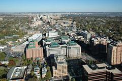
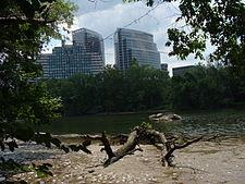
All About Arlington, Virginia Geographic Area


Arlington County is a county in the Commonwealth of Virginia. The land that became Arlington was originally donated by Virginia to the United States government to form part of the new federal capital district. On February 27, 1801, the United States Congress organized the area as a subdivision of the District of Columbia named Alexandria County. In 1846, Congress returned the land donated by Virginia due to issues involving Congressional representation and the abolition of slavery. The General Assembly of Virginia changed the county's name to Arlington in 1920 to avoid confusion with the adjacent City of Alexandria.
The county is situated in Northern Virginia on the south bank of the Potomac River directly across from Washington, D.C. Arlington is also bordered by Fairfax County and the City of Falls Church to the southwest, and the City of Alexandria to the southeast. With a land area of 26 square miles (67 km2), Arlington is the geographically smallest self-governing county in the United States and has no other incorporated towns within its borders. Given these unique characteristics, for statistical purposes the county is included as a municipality within the Washington Metropolitan Area by the United States Census Bureau. As of 2010, Arlington County had a population of 207,627 residents. It would be the fourth-largest city in the state if it were incorporated as such.
Given the county's proximity to Washington, D.C., Arlington is headquarters to many departments and agencies of the federal government of the United States, including the Pentagon, the Department of Defense, the United States Drug Enforcement Administration, the Defense Intelligence Agency and the Defense Advanced Research Projects Agency (DARPA). The many federal agencies, government contractors, and service industries contribute to Arlington's stable economy, which has made it one of the highest-income counties in the United States. Arlington is also the location of national memorials and museums, including Arlington National Cemetery, the Pentagon Memorial, the Marine Corps War Memorial, and the United States Air Force Memorial.
The area that now forms Arlington County was originally part of Fairfax County in the Colony of Virginia. Land grants from the British monarch were awarded to prominent Englishmen in exchange for political favors and efforts at development. One of the grantees was Thomas Fairfax, 6th Lord Fairfax of Cameron whose lends his name to both Fairfax County and the City of Fairfax. The name Arlington comes from Henry Bennet, 1st Earl of Arlington whose name had been applied to a plantation along the Potomac River. George Washington Parke Custis, grandson of First Lady Martha Washington, acquired this land in 1802. The estate was eventually passed down to Mary Anna Custis Lee, wife of General Robert E. Lee. The property later became Arlington National Cemetery during the American Civil War, and now lends its name to present-day Arlington County.
The area that now contains Arlington County was ceded to the new United States federal government by the Commonwealth of Virginia. With the passage of the Residence Act in 1790, Congress approved a new permanent capital to be located on the Potomac River, the exact area to be selected by President George Washington. The Residence Act originally only allowed the President to select a location within Maryland as far east as what is now the Anacostia River. However, President Washington shifted the federal territory's borders to the southeast in order to include the pre-existing city of Alexandria at the District's southern tip. In 1791, Congress amended the Residence Act to approve the new site, including the territory ceded by Virginia. However, this amendment to the Residence Act specifically prohibited the "erection of the public buildings otherwise than on the Maryland side of the River Potomac." As permitted by the U.S. Constitution, the initial shape of the federal district was a square, measuring 10 miles (16 km) on each side, totaling 100 square miles (260 km2). During 1791 ae92, Andrew Ellicott and several assistants placed boundary stones at every mile point. Fourteen of these markers were in Virginia and many of the stones are still standing.
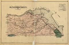
When Congress arrived in the new capital, they passed the Organic Act of 1801 to officially organize the District of Columbia and placed the entire federal territory, including the cities of Washington, Georgetown, and Alexandria, under the exclusive control of Congress. Further, the unincorporated territory within the District was organized into two counties: the County of Washington to the east of the Potomac and the County of Alexandria to the west. This Act formally established the borders of the area that would eventually become Arlington but the citizens located in the District were no longer considered residents of Maryland or Virginia, thus ending their representation in Congress.
Residents of Alexandria County had expected the federal capital's location to result in land sales and the growth of commerce. Instead the county found itself struggling to compete with the Chesapeake and Ohio Canal at the port of Georgetown, which was farther inland and on the northern side of the Potomac River next to the City of Washington. Members of Congress from other areas of Virginia also used their power to prohibit funding for projects, such as the Alexandria Canal, which would have increased competition with their home districts. In addition, Congress had prohibited the federal government from establishing any offices in Alexandria, which made the county less important to the functioning of the national government.
Alexandria had also been a major market in the American slave trade, and rumors circulated that abolitionists in Congress were attempting to end slavery in the District; such an action would have further depressed Alexandria's slavery-based economy. At the same time, an active abolitionist movement arose in Virginia that created a division on the question of slavery in the Virginia General Assembly. Pro-slavery Virginians recognized that if Alexandria were returned to the Commonwealth, it could provide two new representatives who favored slavery in the state legislature. During the American Civil War, this division led to the formation of the state of West Virginia, which comprised the 55 counties in the northwest that favored abolitionism.
Largely as a result of the economic neglect by Congress, divisions over slavery, and the lack of voting rights for the residents of the District, a movement grew to return Alexandria to Virginia from the District of Columbia. From 1840 to 1846, Alexandrians petitioned Congress and the Virginia legislature to approve this transfer known as retrocession. On February 3, 1846, the Virginia General Assembly agreed to accept the retrocession of Alexandria if Congress approved. Following additional lobbying by Alexandrians, Congress passed legislation on July 9, 1846, to return all the District's territory south of the Potomac River back to the Commonwealth of Virginia, pursuant to a referendum; President James K. Polk signed the legislation the next day. A referendum on retrocession was held on September 1 ae2, 1846. The residents of the City of Alexandria voted in favor of the retrocession, 734 to 116; however, the residents of Alexandria County voted against retrocession 106 to 29. Despite the objections of those living in Alexandria County, President Polk certified the referendum and issued a proclamation of transfer on September 7, 1846. However, the Virginia legislature did not immediately accept the retrocession offer. Virginia legislators were concerned that the people of Alexandria County had not been properly included in the retrocession proceedings. After months of debate, the Virginia General Assembly voted to formally accept the retrocession legislation on March 13, 1847. In 1852, the Virginia legislature voted to incorporate a portion of Alexandria County to make the City of Alexandria, which until then had been only been considered politically as a town.
During the American Civil War, Virginia seceded from the Union as a result of a statewide referendum held on May 23, 1861; the voters from Alexandria County approved secession by a vote of 958 ae48. This vote indicates the degree to which its only town, Alexandria, was pro-secession and pro-Confederate. The Union loyalists who lived in rural areas outside the town of Alexandria, rejected secession. Although Virginia was part of the Confederacy, its control did not extend all the way through Northern Virginia. In 1862, the United States Congress passed a law that provided that those districts in which the "insurrection" persisted were to pay their real estate taxes in person.
In 1864, during the war, the federal government confiscated the Abingdon estate, which was located on and near the present Ronald Reagan Washington National Airport, when its owner failed to pay the estate's property tax in person because he was serving in the Confederate Army. The government then sold the property at auction, whereupon the purchaser leased the property to a third party.
After the war ended in 1865, the Abingdon estate's heir, Alexander Hunter, initiated a legal action to recover the property. James A. Garfield, a Republican member of the United States House of Representatives who had been a Brigadier General in the Union Army during the Civil War and who later became the 20th President of the United States, was an attorney on Hunter's legal team. In 1870, the Supreme Court of the United States, in a precedential ruling, found that the government had illegally confiscated the property and ordered that it be returned to Hunter.
The property containing the home of Confederate General Robert E. Lee's family at and around Arlington House was subjected to an appraisal of $26,810, on which a tax of $92.07 was assessed. However, Lee's wife, Mary Anna Custis Lee, the owner of the property, did not pay this tax in person. As a result of the 1862 law, the Federal government confiscated the property and made it into a military cemetery.
After the war ended and after the death of his parents, George Washington Custis Lee, the Lee's eldest son, initiated a legal action in an attempt to recover the property. In December 1882, the U.S. Supreme Court found that the federal government had illegally confiscated the property without due process and returned the property to Custis Lee while citing the Court's earlier ruling in the Hunter case. In 1883, the U.S. Congress purchased the property from Lee for $150,000, whereupon the property became a military reservation and eventually Arlington National Cemetery. Although Arlington House is within the National Cemetery, the National Park Service presently administers the House and its grounds as a memorial to Robert E. Lee.
Confederate incursions from Falls Church, Minor's Hill and Upton's Hill ae-then securely in Confederate hands ae-occurred as far east as the present-day area of Ballston. On August 17, 1861 an armed force of 600 Confederate soldiers engaged the 23rd New York Infantry near that crossroads, killing one. Another large incursion on August 27 involved between 600 and 800 Confederate soldiers, which clashed with Union soldiers at Ball aos Crossroads, Hall aos Hill and along the modern-day border between the City of Falls Church and Arlington. A number of soldiers on both sides were killed. However, the territory in present-day Arlington was never successfully captured by Confederate forces.
In 1896, an electric trolley line was built from Washington through Ballston, which led to growth in the county.
In 1920, the Virginia legislature renamed the area Arlington County to avoid confusion with the City of Alexandria which had become an independent city in 1870 under the new Virginia Constitution adopted after the Civil War.
In the 1930s, Hoover Field was established on the present site of the Pentagon; in that decade, Buckingham, Colonial Heights, and other apartment communities also opened. World War II brought a boom to the county, but one that could not be met by new construction due to rationing imposed by the war effort.
In October 1942, not a single rental unit was available in the county. The Henry G. Shirley Highway (now Interstate 395) was constructed during World War II, along with adjacent developments such as Shirlington, Fairlington, and Parkfairfax.
On September 11, 2001, five al-Qaeda hijackers deliberately crashed American Airlines Flight 77 into The Pentagon killing 125 Pentagon personnel and all 64 people on board, as part of the September 11 attacks.
According to the U.S. Census Bureau, the county has a total area of 26 square miles (67.3 km2), of which about 4.6 square miles (11.9 km2) is federal property. The county is roughly in the shape of a rectangle 4 miles (6.4 km) by 6 miles (9.7 km), with the small end slanting in a northwest-southeast direction. All cities within the Commonwealth of Virginia are independent of counties, though towns may be incorporated within counties. However, Arlington has no existing incorporated towns because Virginia law prevents the creation of any new municipality within a county that has a population density greater than 1,000 persons per square mile. Its county seat is the census-designated place (CDP) of Arlington, which is coterminous with the boundaries of the county; however, the county courthouse and most government offices are located in the Courthouse neighborhood.
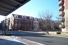
There are a number of unincorporated neighborhoods within Arlington that are commonly referred to by name as if they were distinct towns. For over 30 years, the government has pursed a development strategy of concentrating much of its new development near transit facilities, such as Metrorail stations and the high-volume bus lines of Columbia Pike. Within the transit areas, the government has a policy of encouraging mixed-use and pedestrian- and transit-oriented development. Some of these "urban village" communities include:
In 2002, Arlington received the EPA's National Award for Smart Growth Achievement for "Overall Excellence in Smart Growth." In 2005, the County implemented an affordable housing ordinance that requires most developers to contribute significant affordable housing resources, either in units or through a cash contribution, in order to obtain the highest allowable amounts of increased building density in new development projects, most of which are planned near Metrorail station areas.
A number of the county's residential neighborhoods and larger garden-style apartment complexes are listed in the National Register of Historic Places and/or designated under the County government's zoning ordinance as local Historic Preservation Districts. These include Arlington Village, Arlington Forest, Ashton Heights, Buckingham, Cherrydale, Claremont, Colonial Village, Fairlington, Lyon Park, Lyon Village, Maywood, Penrose, Waverly Hills and Westover. Many of Arlington County's neighborhoods participate in the Arlington County government's Neighborhood Conservation Program (NCP). Each of these neighborhoods has a Neighborhood Conservation Plan that describes the neighborhood's characteristics, history and recommendations for capital improvement projects that the County government funds through the NCP.
The United States Census Bureau found that there were 207,627 residents as of April 1, 2010.
As of the 2000 census, there were:
The population density was 7,323 people per square mile (2,828/km ²), the highest of any county in Virginia. There were 90,426 housing units at an average density of 3,495/sq mi (1,350/km ²).
In 2010, the racial makeup of the county was:
There were 86,352 households out of which 19.30% had children under the age of 18 living with them, 35.30% were married couples living together, 7.00% had a female householder with no husband present, and 54.50% were non-families. 40.80% of all households were made up of individuals and 7.30% had someone living alone who was 65 years of age or older. The average household size was 2.15 and the average family size was 2.96.
Families headed by single parents was the lowest in the DC area, under 6%, as estimated by the Census Bureau for the years 2006 ae2008. For the same years, the percentage of people estimated to be living alone was the third highest in the DC area, at 45%.
According to a 2007 estimate, the median income for a household in the county was $94,876, and the median income for a family was $127,179. Males had a median income of $51,011 versus $41,552 for females. The per capita income for the county was $37,706. About 5.00% of families and 7.80% of the population were below the poverty line, including 9.10% of those under age 18 and 7.00% of those age 65 or over.
In 2009, the county was second in the nation (after nearby Loudoun County) for the percentage of people ages 25 ae34 earning over $100,000 annually (8.82% of the population).
In 2009, Arlington was highest in the Washington DC Metropolitan area for percentage of people who were single ae 70.9%. 14.3% were married. 14.8% had families.
The age distribution was 16.50% under 18, 10.40% from 18 to 24, 42.40% from 25 to 44, 21.30% from 45 to 64, and 9.40% who were 65 or older. The median age was 34 years. For every 100 females there were 101.50 males. For every 100 females age 18 and over, there were 100.70 males.
CNN Money ranked Arlington as the most educated city in 2006 with 35.7% of residents having held graduate degrees. Along with five other counties in Northern Virginia, Arlington ranked among the twenty American counties with the highest median household income in 2006. In August 2011, CNN Money ranked Arlington seventh in the country in its listing of "Best Places for the Rich and Single."
In 2008, 20.3% of the population did not have medical health insurance.
In 2010, AIDS prevalence was 341.5 per 100,000 population. This was eight times the rate of nearby Loudoun County and one-quarter the rate of the District of Columbia.
Crime statistics for 2009 included the report of 2 homicides, 15 forcible rapes, 149 robberies, 145 incidents of or aggravated assault, 319 burglaries, 4,140 incidents of larceny, and 297 reports of vehicle theft. This was a reduction in all categories from the previous year.
Arlington County is the smallest self-governing county in the United States. The county is governed by a five person County Board, whose members are elected at-large to staggered four year terms. They appoint a county manager, who is the chief executive of the County Government. Like all Virginia Counties, Arlington also has five elected constitutional officers: a sheriff, a clerk of court, a commonwealth's attorney, a treasurer, and a commissioner of the revenue. The budget for fiscal year 2009 was $1.177 billion.
Arlington County is one of the most Democratic regions in Virginia. It last supported a Republican for president in 1980, and all elected officials in the county are Democrats.
In 2009, as the state was voting for Republican Bob McDonnell for governor by a 59% to 41% margin, Arlington voted for Democrat Creigh Deeds 66% to 34%. Voter turnout was 42.78%. Arlington also elects four Members of the 100 Member Virginia House of Delegates and two Members of the Virginia Senate. State Senators are elected to four year terms, while Delegates are elected to two year terms. The county is included within Virginia's 8th congressional district, currently represented by Democrat Jim Moran.
Arlington is governed or represented by three of the four openly gay elected officials in Virginia. Arlington County Board member Jay Fisette was the first in 1997. Adam Ebbin became the first openly gay Delegate in 2003. In 2006, School Board member Sally Baird became the first openly lesbian elected official in Virginia. (The fourth openly gay elected official is Councilman Paul Smedberg of the City of Alexandria Council.)
The United States Postal Service designates zip codes starting with "222" for exclusive use in Arlington County. As a result of the unique relationship of some institutions to the federal government, Ronald Reagan Washington National Airport and The Pentagon both use Washington, D.C. as their address and have zip codes that begin with the digits "20" even though each is actually located in Arlington County.
Arlington has consistently had the lowest unemployment rate of any jurisdiction in Virginia. The unemployment rate in Arlington was 4.2% in August 2009. 60% of office space in the Rosslyn-Ballston corridor is leased to government agencies and government contractors. There were an estimated 205,300 jobs in the county in 2008. About 28.7% of these were with the federal, state or local government; 19.1% technical and professional; 28.9% accommodation, food and other services.
In October 2008, BusinessWeek ranked Arlington as the safest city in which to weather a recession, with a 49.4% share of jobs in "strong industries". In October 2009, during the economic downturn, the unemployment in the county reached 4.2%. This was the lowest in the state, which averaged 6.6% for the same time period, and among the lowest in the nation, which averaged 9.5% for the same time.
In 2010, there were an estimated 90,842 residences in the county. In 2000, the median single family home price was $262,400. About 123 homes were worth $1 million or more. In 2008, the median home was worth $586,200. 4,721 houses, about 10% of all stand-alone homes, were worth $1 million or more.
In 2010, there were 0.9 percent of the homes in foreclosure. This was the lowest rate in the DC area.
A number of federal agencies are headquartered in Arlington, including the Air Force Office of Scientific Research, DARPA, Drug Enforcement Administration, Foreign Service Institute, National Science Foundation, Office of Naval Research, Transportation Security Administration, United States Department of Defense, United States Fish and Wildlife Service, United States Marshals Service, and the United States Trade and Development Agency.
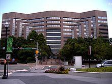
Companies headquartered in Arlington include AES, Allbritton Communications Company, Alcalde and Fay, Arlington Asset Investment, CACI, Corporate Executive Board, ENVIRON International Corporation, ESI International, FBR Capital Markets, Interstate Hotels & Resorts, Rosetta Stone and Strayer Education.
Organizations located here include Associated General Contractors, The Conservation Fund, Conservation International, the Consumer Electronics Association, The Fellowship, the Feminist Majority Foundation, the Insurance Institute for Highway Safety, the National Rural Electric Cooperative Association, The Nature Conservancy, the Public Broadcasting Service, United Service Organizations and the US-Taiwan Business Council.
According to the County's 2009 Comprehensive Annual Financial Report, the top employers in the county are:
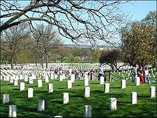
Arlington National Cemetery is an American military cemetery established during the American Civil War on the grounds of Confederate General Robert E. Lee's home, Arlington House (also known as the Custis-Lee Mansion). It is directly across the Potomac River from Washington, D.C., north of the Pentagon. With nearly 300,000 people buried there, Arlington National Cemetery is the second-largest national cemetery in the United States.
Arlington House was named after the Custis family's homestead on Virginia's Eastern Shore. It is associated with the families of Washington, Custis, and Lee. Begun in 1802 and completed in 1817, it was built by George Washington Parke Custis. After his father died, young Custis was raised by his grandmother and her second husband, the first US President George Washington, at Mount Vernon. Custis, a far-sighted agricultural pioneer, painter, playwright, and orator, was interested in perpetuating the memory and principles of George Washington. His house became a "treasury" of Washington heirlooms.
In 1804, Custis married Mary Lee Fitzhugh. Their only child to survive infancy was Mary Anna Randolph Custis, born in 1808. Young Robert E. Lee, whose mother was a cousin of Mrs. Custis, frequently visited Arlington. Two years after graduating from West Point, Lieutenant Lee married Mary Custis at Arlington on June 30, 1831. For 30 years, Arlington House was home to the Lees. They spent much of their married life traveling between U.S. Army duty stations and Arlington, where six of their seven children were born. They shared this home with Mary's parents, the Custis family.
When George Washington Parke Custis died in 1857, he left the Arlington estate to Mrs. Lee for her lifetime and afterward to the Lees' eldest son, George Washington Custis Lee.
The U.S. government confiscated Arlington House and 200 acres (81 ha) of ground immediately from the wife of General Robert E. Lee during the Civil War. The government designated the grounds as a military cemetery on June 15, 1864, by Secretary of War Edwin M. Stanton. In 1882, after many years in the lower courts, the matter of the ownership of Arlington National Cemetery was brought before the United States Supreme Court. The Court decided that the property rightfully belonged to the Lee family. The United States Congress then appropriated the sum of $150,000 for the purchase of the property from the Lee family.
Veterans from all the nation's wars are buried in the cemetery, from the American Revolution through the military actions in Afghanistan and Iraq. Pre-Civil War dead were re-interred after 1900.
The Tomb of the Unknowns, also known as the Tomb of the Unknown Soldier, stands atop a hill overlooking Washington, DC. President John F. Kennedy is buried in Arlington National Cemetery with his wife and some of their children. His grave is marked with an "Eternal Flame." His brothers, Senators Robert F. Kennedy and Edward M. Kennedy, are also buried nearby. Another President, William Howard Taft, who was also a Chief Justice of the U.S. Supreme Court, is the only other President buried at Arlington.
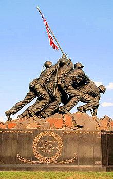
Other frequently visited sites near the cemetery are the U.S. Marine Corps War Memorial, commonly known as the "Iwo Jima Memorial", the U.S. Air Force Memorial, the Women in Military Service for America Memorial, the Netherlands Carillon and the U.S. Army's Fort Myer.
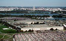
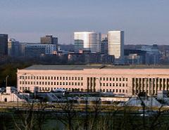
The Pentagon in Arlington is the headquarters of the United States Department of Defense. It was dedicated on January 15, 1943 and it is the world's largest office building. Although it is located in Arlington, the United States Postal Service requires that "Washington, D.C." be used as the place name in mail addressed to the six ZIP codes assigned to The Pentagon.
The building is pentagon-shaped in plan and houses about 23,000 military and civilian employees and about 3,000 non-defense support personnel. It has five floors and each floor has five ring corridors. The Pentagon's principal law enforcement arm is the United States Pentagon Police, the agency that protects the Pentagon and various other DoD jurisdictions throughout the National Capital Region.
Built during the early years of World War II, it is still thought of as one of the most efficient office buildings in the world. It has 17.5 miles (28 km) of corridors, yet it takes only seven minutes or so to walk between any two points in the building.
It was built from 680,000 short tons (620,000 t) of sand and gravel dredged from the nearby Potomac River that were processed into 435,000 cubic yards (330,000 m ³) of concrete and molded into the pentagon shape. Very little steel was used in its design due to the needs of the war effort.
The open-air central plaza in the Pentagon is the world's largest "no-salute, no-cover" area (where U.S. servicemembers need not wear hats nor salute). The snack bar in the center is informally known as the Ground Zero Cafe, a nickname originating during the Cold War when the Pentagon was targeted by Soviet nuclear missiles.
During World War II, the earliest portion of the Henry G. Shirley Memorial Highway was built in Arlington in conjunction with the parking and traffic plan for the Pentagon. This early freeway, opened in 1943, and completed to Woodbridge, Virginia in 1952, is now part of Interstate 395.

Arlington forms part of the region's core transportation network. The county is traversed by two interstate highways, Interstate 66 in the northern part of the county and Interstate 395 in the eastern part, both with high-occupancy vehicle lanes or restrictions. In addition, the county is served by the George Washington Memorial Parkway. In total, Arlington County maintains 376 miles (605 km) of roads.
The street names in Arlington generally follow a unified countywide convention. The north-south streets are generally alphabetical, starting with one-syllable names, then two-, three- and four-syllable names. The "lowest" alphabetical street is Ball Street. The "highest" is Arizona. Many east-west streets are numbered. Route 50 divides Arlington County. Streets are generally labeled North above Route 50, and South below.
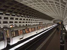
Arlington is served by the Orange, Blue and Yellow lines of the Washington Metro. Additionally, it is served by Virginia Railway Express commuter rail, Metrobus (regional public bus), Fairfax Connector (regional public bus), Potomac and Rappahannock Transportation Commission (PRTC) (regional public bus), and a county public bus system, Arlington Transit (ART).
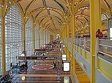
Arlington County is home to Ronald Reagan Washington National Airport, which provides domestic air services to the Washington, D.C. area. In 2009, Conde Nast Traveler readers voted it the country's best airport. Nearby international airports are Washington Dulles International Airport, located in Fairfax and Loudoun counties in Virginia, and Baltimore-Washington International Thurgood Marshall Airport, located in Anne Arundel County, Maryland.
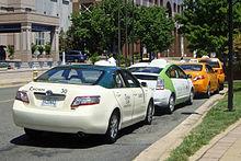
In 2007, the county authorized EnviroCAB, a new taxi company, to operate exclusively with a hybrid-electric fleet of 50 vehicles and also issued permits for existing companies to add 35 hybrid cabs to their fleets. As operations began in 2008, EnvironCab became the first all-hybrid taxicab fleet in the U.S. and the company not only offsets the emissions generated by its fleet of hybrids, but also the equivalent emissions of 100 non-hybrid taxis in service in the metropolitan area. The green taxi expansion is part of a county campaign known as Fresh AIRE, or Arlington Initiative to Reduce Emissions, that aims to cut production of greenhouse gases from county buildings and vehicles by 10 percent by 2012.
Arlington has 86 miles (138 km) of on-street and paved off-road bicycle trails. Off-road trails travel along the Potomac River or its tributaries, abandoned railroad beds, or major highways, including: Four Mile Run Trail that travels the length of the county; the Custis Trail, which runs the width of the county from Rosslyn; the Washington & Old Dominion Railroad Trail (W&OD Trail) that travels 45 miles (72 km) from the Shirlington neighborhood out to western Loudoun County; the Mount Vernon Trail that runs for 17 miles (27 km) along the Potomac, continuing through Alexandria to Mount Vernon.
Capital Bikeshare, a bicycle sharing system, began operations in September 2010 with 14 rental locations primarily around Washington Metro stations in throughout the county.
Arlington Public Schools operates the county's public K-12 education system of 22 elementary schools, 5 middle schools, and 4 public high schools in Arlington County including Wakefield High School, Washington-Lee High School, Yorktown High School and the H-B Woodlawn alternative school. Arlington County spends about half of its local revenues on education, making it one of the top ten per-pupil spenders in the nation. As of 2004, over $13,000, the second highest amount spent on education in the United States, behind New York City.
Arlington has an elected five-person school board whose members are elected to four year terms. Virginia law does not permit political parties to place school board candidates on the ballot.
Through an agreement with Fairfax County Public Schools approved by the school board in 1999, up to 26 students residing in Arlington per grade level may be enrolled at the Thomas Jefferson High School for Science and Technology in Fairfax at a cost to Arlington of approximately $8000 per student. For the first time in 2006, more students (36) were offered admission in the selective high school than allowed by the previously established enrollment cap.
Marymount University is the only university with its main campus located in Arlington. Founded in 1950 by the Religious of the Sacred Heart of Mary as Marymount College of Virginia, both its main campus and its Ballston Center are located on North Glebe Road, with a shuttle service connecting the two.
George Mason University operates an Arlington campus in the Virginia Square area between Clarendon and Ballston. The campus houses the George Mason University School of Law, School of Public Policy and other programs.
In June 2011, Virginia Tech opened the Virginia Tech Research Center - Arlington in Ballston, providing a teaching and research base for graduate students in computer research and engineering to interact with organizations and research agencies in the National Capital area.
Other private and technical schools maintain a campus in Arlington, including the Institute for the Psychological Sciences, the John Leland Center for Theological Studies, the University of Management and Technology, The Art Institute of Washington, DeVry University. Strayer University has a campus in Arlington as well as its corporate headquarters.
In addition, Argosy University, Banner College, Everest College, George Washington University, Georgetown University, Northern Virginia Community College, Troy University, the University of New Haven, the University of Oklahoma, and Westwood College all have campuses in Arlington.
Arlington has five sister cities, as designated by Sister Cities International:
Word Count: 6143