


Clarksville, Tennessee, Hgh State Clinic, Hgh Injections, Hrt Doctors


Clarksville, Tennessee Blood Testing Facilities
 Represents a LabCorp blood testing facility
 Represents a Quest Diagnostics blood testing facility

Nearby Labcorp Blood Testing facilities:
- Labcorp Center Distance: 4 m, 286 Clear Sky Court Suite C, Clarksville, Montgomery County, TN, 37043
- Labcorp Center Distance: 47 m, 1400 Donelson Pike Ste B10, Nashville, Davidson County, TN, 37217
- Labcorp Center Distance: 51 m, 100 Medical Center Drive, Princeton, Caldwell County, KY, 42445
- Labcorp Center Distance: 58 m, 5421 Main Street, Spring Hill, Maury County, TN, 37174
- Labcorp Center Distance: 64 m, 854 West James Campbell Blvd, Columbia, Maury County, TN, 38401
- Labcorp Center Distance: 65 m, 1220 Trotwood, Columbia, Maury County, TN, 38401
- Labcorp Center Distance: 69 m, 520 West Gum St, Marion, Crittenden County, KY, 42064
- Labcorp Center Distance: 78 m, 130 Lebanon Hwy, Carthage, Smith County, TN, 37030
- Labcorp Center Distance: 79 m, 158 Hospital Dr, Carthage, Smith County, TN, 37030
- Labcorp Center Distance: 80 m, 225 Medical Center Dr Ste 408, Paducah, McCracken County, KY, 42003
- Labcorp Center Distance: 82 m, 4630 Village Sq Dr Suite 103, Paducah, McCracken County, KY, 42001
- Labcorp Center Distance: 83 m, 2835 Highway 231 N, Shelbyville, Bedford County, TN, 37160
- Labcorp Center Distance: 86 m, 2121 North Locust Avenue, Lawrenceburg, Lawrence County, TN, 38464
- Labcorp Center Distance: 99 m, 1200 Professional Blvd, Evansville, Vanderburgh County, IN, 47714
Nearby Quest Blood Testing facilities:
- Quest Center Distance: 5 m, 751 Chesapeake Ln Ste 103, Clarksville, Montgomery County, TN, 37040-5263
- Quest Center Distance: 39 m, 1916 Patterson St, Nashville, Davidson County, TN, 37203-2164
- Quest Center Distance: 49 m, 2001 Mallory Ln, Franklin, Williamson County, TN, 37067-8233
- Quest Center Distance: 60 m, 115 Winwood Dr, Lebanon, Wilson County, TN, 37087-3133
- Quest Center Distance: 69 m, 536 N. Thompson Lane Ste F, Murfreesboro, Rutherford County, TN, 37129-4301
Tennessee Hormone Replacement Therapy Services
Are you over the age of thirty and feel that your body is slowing down more quickly than it should? Hormone Imbalance can have a tremendously negative impact on human health and well-being, leading to premature aging and increasing the risk of a variety of different health conditions which are exacerbated by age and poor health.
The Conscious Evolution Institute provides HRT treatments to citizens all across the state of Tennessee, and we have affiliate physicians located in every county of the state that can help you get the treatment you need and deserve to preserve your health and longevity well into old age.
Tennessee Low-T Treatments
Testosterone Deficiency affects millions of men across the United States. When most people think about Low-T, they think about Erectile Dysfunction and other sexual issues, but did you know that Low-T can actually be dangerous for your health? Age-Related Testosterone Deficiency (also known as Andropause) is associated with a wide variety of health risks which can shorten your life, including heart disease, diabetes, obesity, and stroke.
Bio-Identical Testosterone Hormone Replacement Therapy is a proven method to restore healthy and youthful levels of Testosterone, not only improving your sexual health and ability, but reducing the risk of a variety of age-related threats to your health and wellness.
Tennessee HCG Weight Loss Therapy
Everyone that has ever struggled with their weight understands how difficult it is to lose weight and keep it off. If you are overweight or obese and you simply can't find a diet plan that works for you, HCG Injections may be the solution that you've been looking for.
HCG is a hormone naturally produced by the human body which has the ability to both encourage weight loss via adipose fat and reduce the hunger pangs associated with dieting, making it easier to control cravings and lose weight. When combined with a strategy known as caloric restriction, HCG Injections can effectively allow patients to lose a pound or more per day. Men and women all across the country have experienced the power of HCG, and you can too!
HGH and Sermorelin Acetate Treatments for Human Growth Hormone Deficiency
HGH Deficiency is a major medical condition which significantly impacts health and wellness, and unfortunately, our bodies produce less and less of the hormone as we grow older. Human Growth Hormone stimulates and sustains cellular metabolism, and impacts the health of every organ system and even every cell in the human body.
As HGH Levels decline with age, the body becomes less resilient and less able to rehabilitate and restore itself in response to the normal wear and tear of everyday life. Luckily, there are highly effective methods to restore optimal HGH Levels in the body. Physician-Monitored HGH Injections directly supplement the body's own production of natural Human Growth Hormone to restore youthful levels, and Sermorelin Acetate Injections encourage the body to produce optimal endogenous HGH by safely stimulating the Pituitary Gland.
Major Cities in Tennessee
Memphis
Memphis is the largest city in Tennessee and has the second largest metropolitan population. Memphis is located in the southwestern corner of Tennessee, along the Mississippi River. The metro area extends into both Arkansas and Mississippi. Memphis is most famous for its popular entertainment district, Beale Street. The National Civil Rights Museum and Elvis' Graceland are also located in the city.
Memphis is home to one professional sports team: The Memphis Grizzlies. The Memphis Grizzlies play at FedEx Forum, and FedEx is one of the largest employers in the region. The basketball team of the University of Memphis also plays at FedEx Forum.
Nashville
Nashville is the second largest city in Tennessee and represents the largest metropolitan area. The city is also the state capital of Tennessee. Nashville is located in the heart of the state. Nashville is nationally recognized as the country music capital of the world, and has a large and diverse music scene.
Nashville has a strong economy which revolves around a number of different fields, including transportation, banking, publishing, healthcare, and music. The University of Vanderbilt, one of the premier private universities in the south, is located in downtown Nashville. Nashville is also home to the NFL team, the Tennessee Titans
Knoxville
Knoxville, Tennessee is the third largest city in the state, and is located along the border of the smoky mountains in east-central Tennessee. The metro area is also the third largest in Tennessee. Knoxville is well known in the south as a college city, and is home to the University of Tennessee. Their football team, the Tennessee Volunteers, play at Neyland Stadium, which is one of the biggest sports stadiums on the planet.
Knoxville began as a significant city for textile and manufacturing, but has developed considerably over the last fifty years. Knoxville is recognized for having strong economic opportunities combined with a low cost of living. The biggest company operating out of Knoxville is Regal Entertainment Group, which operates movie theaters throughout the country.
Chattanooga
Chattanooga is the fourth largest city and metro in Tennessee, located along the border of Georgia and Tennessee, straddling the Tennessee River immediately next to Lookout Mountain. Chattanooga is often referred to by the nickname, the Scenic City, for its tremendous variety of outdoor attractions, from camping to cave exploration to rock climbing.
Chattanooga was historically the center for the steel industry in the Tennessee Valley, but has developed quite a reputation for entertainment and tourism. Among the tourist attractions located in Chattanooga are the Chattanooga Choo Choo, Ruby Falls, the Tennessee Aquarium, and Rock City.
Clarksville
Clarksville is the fifth largest city in Tennessee, and the sixth largest metropolitan area slightly behind Bristol Tennessee/Virginia. Clarksville is located in north-central Tennessee very close to Kentucky. Clarksville is located on the Cumberland River. Although not located in Clarksville, the U.S. Army Base Fort Campbell is located just miles away and is one of the biggest employers of the region.
Clarksville is home to Austin Peay University. Among the largest employers in Clarksville, Tennessee are Convergys Corporation, Bridgestone Metalpha USA, American Standard, and Agero, Incorporated.
All About Clarksville, Tennessee Geographic Area
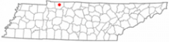
Clarksville is a city in and the county seat of Montgomery County, Tennessee, and the fifth-largest city in the state. The population was 132,929 in the 2010 United States Census. Clarksville is the ninth-fastest growing city in the nation.
It is the principal central city of the Clarksville, TN-KY metropolitan statistical area, which consists of Montgomery and Stewart counties, Tennessee; and Christian and Trigg counties, Kentucky. It is the tenth fastest-growing Metropolitan Statistical Area (MSA) in the nation.
The city was incorporated in 1785 as Tennessee's first incorporated city, and named for General George Rogers Clark, frontier fighter and Revolutionary War hero, and brother of William Clark of the Lewis and Clark Expedition.
Clarksville is the home of Austin Peay State University; The Leaf-Chronicle, the oldest newspaper in Tennessee; and neighbor to the Fort Campbell, United States Army base. Site of the 101st Airborne Division (Air Assault), Fort Campbell is located approximately ten miles (16 km) from downtown Clarksville, straddling the Tennessee-Kentucky state line. It is officially Fort Campbell, Kentucky as the base U.S. Post Office is on the Kentucky side of the post. The majority of the acreage of Fort Campbell is within the state of Tennessee.
Clarksville is located at 36 °31 a²47 a³N 87 °21 a²33 a³W / 36.52972 °N 87.35917 °W / 36.52972; -87.35917 (36.5297222, -87.3594444). The elevation is 382 feet (116 m) above sea level. This altitude can be found on a section of Riverside Drive, which runs along the eastern bank of the Cumberland, but most of the city is higher. Clarksville's civil airport, Outlaw Field, is listed as 550 feet (170 m) AMSL by survey. According to Topo USA mapping software, the city square sits at 475 feet (145 m) and the courthouse at 509 feet (155 m). There is a point on the northern side of Memorial Drive near Medical Court that reaches 598 feet (182 m).
According to the United States Census Bureau, the city has a total area of 95.5 square miles (247 km2), of which 94.9 square miles (246 km2) is land and 0.7 square miles (1.8 km2) (0.71%) is water.
Clarksville is located on the northwest edge of the Highland Rim, which surrounds the Nashville Basin, and is 45 miles (72 km) northwest of Nashville.
Clarksville was founded on the Cumberland River near the confluence of the Cumberland and the Red River. The Cumberland flows downstream from Nashville, some 40 miles (64 km) southeast of Clarksville. From its beginnings, the river was the city's commercial lifeline. Flat boats and, by the 1820s, steamboats carried cotton, oats, soybeans and tobacco, downstream to the Ohio River and up the Ohio to Pittsburgh. More frequently, cargo went down the Ohio to the Mississippi River and New Orleans. Both dark-fired and burley tobacco are grown in the area, and European tobacco buyers helped make Clarksville the largest market in the world for dark-fired tobacco, particularly Type 22, used in smokeless products. It was considered to have the highest nicotine content of all tobaccos in the 19th century.
To the northwest of Clarksville lies the Fort Campbell Military Reservation, home of the 101st Airborne Division. Much of Clarksville's economy can be attributed to Fort Campbell's presence (and Austin Peay State University). Most of Fort Campbell is in Tennessee, mostly in Montgomery and Stewart counties. Its post office is in Kentucky.
Fort Campbell North is a Census-designated place(CDP) in Christian County, Kentucky. It contains most of the housing for the Fort Campbell Army base. The population was 14,338 at the 2000 census.
Fort Campbell North is part of the Clarksville, TN aeKY Metropolitan Statistical Area
The ZIP codes used in the Clarksville area are: 37010, 37040, 37041, 37042, 37043, 37044, 37191.
Clarksville and the majority of Montgomery County use the area code 931, but a portion of eastern Montgomery County has use of the area code 615. Its neighbor, Fort Campbell, uses area code 270.
As of the census of 2010, there were 132,929 people, 46,512 households, and 32,968 families residing in the city. The racial makeup of the city was 65.6% White, 23.23% African American, 0.6% Native American, 2.3% Asian, 0.5% Pacific Islander, 2.61% from other races, and 5.1% from two or more races. Hispanic or Latino of any race were 9.3% of the population. The census recorded 4.4% foreign-born residents in Clarksville.
There were 46,512 households out of which 38.8% had children under the age of 18 living with them, 48.9% were married couples living together, 17.3% had a female householder with no husband present, and 29.1% were non-families. 23.0% of all households were made up of individuals and 5.1% had someone living alone who was 65 years of age or older. The average household size was 2.63 and the average family size was 3.09.
The median income for a household in the city was $48,679, and the median income for a family was $56,295. Males had a median income of $41,019 versus $31,585 for females. The per capita income for the city was 23,722 (4th highest per capita personal income in Tennessee). About 12.4% of families and 16.5% of the population were below the poverty line, including 23.4% of those under age 18 and 11.5% of those age 65 or over.
The area now known as Tennessee was first settled by Paleo-Indians nearly 11,000 years ago. The names of the cultural groups that inhabited the area between first settlement and the time of European contact are unknown, but several distinct cultural phases have been named by archaeologists, including Archaic, Woodland, and Mississippian whose chiefdoms were the cultural predecessors of the Muscogee people who inhabited the Tennessee River Valley prior to Cherokee migration into the river's headwaters.
When Spanish explorers first visited Tennessee, led by Hernando de Soto in 1539 ae43, it was inhabited by tribes of Muscogee and Yuchi people. Possibly because of European diseases devastating the native tribes, which would have left a population vacuum, and also from expanding European settlement in the north, the Cherokee moved south from the area now called Virginia. As European colonists spread into the area, the native populations were forcibly displaced to the south and west, including all Muscogee and Yuchi peoples, the Chickasaw, and Choctaw. From 1838 to 1839, nearly 17,000 Cherokees were forced to march from "emigration depots" in Eastern Tennessee, such as Fort Cass, to Indian Territory west of Arkansas. This came to be known as the Trail of Tears, as an estimated 4,000 Cherokees died along the way.
The area around Clarksville was first surveyed by Thomas Hutchins in 1768. He identified Red Paint Hill, a rock bluff at the confluence of the Cumberland and Red Rivers, as a navigational landmark.
In the years between 1771 and 1775, John Montgomery, the namesake of the county, along with Kasper Mansker visited the area while on a hunting expedition. In 1771, James Robertson led a group of some twelve or thirteen families involved with the Regulator movement from near where present day Raleigh, North Carolina now stands. In 1772, Robertson and the pioneers who had settled in northeast Tennessee (along the Watauga River, the Doe River, the Holston River, and the Nolichucky River met at Sycamore Shoals to establish an independent regional government known as the Watauga Association. However, in 1772, surveyors placed the land officially within the domain of the Cherokee tribe, who required negotiation of a lease with the settlers. Tragedy struck as the lease was being celebrated, when a Cherokee warrior was murdered by a white man. Through diplomacy, Robertson made peace with the Cherokees, who threatened to expel the settlers by force if necessary.
In March 1775, land speculator and North Carolina judge Richard Henderson met with more than 1,200 Cherokees at Sycamore Shoals, including Cherokee leaders such as Attacullaculla, Oconostota, and Dragging Canoe. In the Treaty of Sycamore Shoals (also known as the Treaty of Watauga), Henderson purchased all the land lying between the Cumberland River, the Cumberland Mountains, and the Kentucky River, and situated south of the Ohio River in what is known as the Transylvania Purchase from the Cherokee Indians. The land thus delineated, 20 million acres (81000 km?), encompassed an area half as large as the present state of Kentucky. Henderson's purchase was in violation of North Carolina and Virginia law, as well as the Royal Proclamation of 1763, which prohibited private purchase of American Indian land. Henderson may have mistakenly believed that a newer British legal opinion had made such land purchases legal.
All of present day Tennessee was once recognized as one single North Carolina county: Washington County, North Carolina. Created in 1777 from the western areas of Burke and Wilkes Counties, North Carolina, Washington County had as a precursor a Washington District of 1775-76, which was the first political entity named for the Commander-in-Chief of American forces in the Revolution.
In 1779, James Robertson brought a group of settlers from upper East Tennessee via Daniel Boone's "Wilderness Road". Robertson would later build an iron plantation in Cumberland Furnace. A year later, John Donelson led a group of flat boats up the Cumberland River bound for the French trading settlement, French Lick (or Big Lick), that would later be Nashville. When the boats reached Red Paint Hill, Moses Renfroe, Joseph Renfroe, and Solomon Turpin, along with their families, branched off onto the Red River. They traveled to the mouth of Parson's Creek, near Port Royal, and went ashore to settle down. However, an attack by Indians in the summer drove them back. (See Port Royal State Park)
Clarksville was designated as a town to be settled in part by soldiers from the disbanded Continental Army that served under General George Washington during the American Revolutionary War. At the end of the war, the federal government lacked sufficient funds to repay the soldiers, so the Legislature of North Carolina, in 1790, designated the lands to the west of the state line as federal lands that could be used in the land grant program. Since the area of Clarksville had been surveyed and sectioned into plots, it was identified as a territory deemed ready for settlement. The land was available to be settled by the families of eligible soldiers as repayment of service to their country.
The development and culture of Clarksville has had an ongoing interdependence between the citizens of Clarksville and the military. The formation of the city is associated with the end of the American Revolutionary War. During the Civil War a large percent of the male population was depleted due to Union Army victories at Fort Henry and Fort Donelson. Many Clarksville men were interned at Union prisoner of war (POW) camps. Clarksville also lost many native sons during World War I. With the formation of Camp Campbell, later Fort Campbell, during World War II, the bonds of military influence were strengthened. Soldiers from Fort Campbell, Kentucky have deployed in every military campaign since the formation of the post.
On January 16, 1784, John Armstrong filed notice with the Legislature of North Carolina to create the town of Clarksville, named after General George Rogers Clark. Even before it was officially designated a town, lots had been sold. In October 1785, Col. Robert Weakley laid off the town of Clarksville for Martin Armstrong and Col. Montgomery, and Weakley had the choice of lots for his services. He selected Lot #20 at the northeast corner of Spring and Main Streets. The town consisted of 20 'squares' of 140 lots and 44 out lots. The original Court House was on Lot #93, on the north side of Franklin Street between Front and Second Street. The Public Spring was on Lot #74, on the northeast corner of Spring and Commerce Streets. Weakley built the first cabin there in January 1786, and about February or March, Col. Montgomery came there and had a cabin built, which was the second house in Clarksville. After an official survey by James Sanders, Clarksville was founded by the North Carolina Legislature on December 29, 1785. It was the second town to be founded in the area. Armstrong's layout for the town consisted of 12 four-acre (16,000 m ²) squares built on the hill overlooking the Cumberland as to protect against floods. The primary streets (from north to south) that went east-west were named Jefferson, Washington (now College Street), Franklin, Main, and Commerce streets. North-south streets (from the river eastward) were named Water (now Riverside Drive), Spring, First, Second, and Third streets.
The tobacco trade in the area was growing larger every year and in 1789, Montgomery and Martin Armstrong persuaded lawmakers to designate Clarksville as an inspection point for tobacco. In 1790, Isacc Rowe Peterson staked a claim to Dunbar Cave, just northeast of downtown.
When Tennessee was founded as a state on June 1, 1796, the area around Clarksville and to the east was named Tennessee County. (This county was established in 1788, by North Carolina.) Later, Tennessee County would be broken up into modern day Montgomery and Robertson counties, named to honor the men who first opened up the region for settlement.
As time progressed into the 19th century, Clarksville grew at a rapid pace. By 1806, the town realized the need for an educational institution, and the Rural Academy was established that year. Later, the Rural Academy would be replaced by the Mount Pleasant Academy. By 1819, the newly-established town had 22 stores, including a bakery and silversmith. In 1820, steamboats begin to navigate the Cumberland, bringing hardware, coffee, sugar, fabric and glass. They also exported flour, tobacco, cotton, and corn to ports such as New Orleans and Pittsburgh along the Ohio and Mississippi Rivers. Trade via land also grew as four main dirt roads were established, two to Nashville, one crossing the Red River via ferry called the Kentucky Road, and Russellville Road. In 1829, the first bridge connecting Clarksville to New Providence was built over the Red River. Nine years later, the Clarksville-Hopkinsville Turnpike was built. In 1855, Clarksville was incorporated as a city. Railroad service came to the town on October 1, 1859 in the form of the Memphis, Clarksville and Louisville Railroad. The line would later connect with other railroads at Paris, Tennessee and Guthrie, Kentucky.
By the start of the Civil War, the combined population of the city and the county was 20,000. The area was openly for slavery, as blacks worked in the tobacco fields. In 1861, both Clarksville and Montgomery County voted unanimously to join the Confederate States of America. The proximity of the birthplace of Confederate President Jefferson Davis; about 20 miles across the border in Fairview, Christian County, Kentucky, gave the city a strong tie to the CSA, and both sides saw the city as strategic and important. Confederate General Albert Sidney Johnston set up a defense line around Clarksville expecting a land attack; however, the Union sent troops and gunboats down the Cumberland River, and in 1862, captured Fort Donelson, Fort Henry, and Clarksville. Between 1862 and 1865, the city would shift hands, but the Union would retain control of Clarksville to include control of the city's newspaper - The Leaf Chronicle for three years. Many slaves that had been freed gathered in Clarksville and joined the Union Army, which created all-black regiments. The remaining lived along the side of the river in shanties.
Clarksville is home to three Confederate States of America Army camps:
On February 17, 1862, the USS Cairo along with another Union Ironclad came to Clarksville, TN and captured the city. There were no Confederate soldiers to contend with because they had left prior to the arrival of the ships. There were white flags flying over Ft. Defiance and over Ft. Clark. The citizens of the town that could get away, left as well. Before they left, Confederate soldiers tried to burn the railroad bridge that crossed the Cumberland River. The fire didn aot take hold and was put out before it could destroy the bridge. This railroad bridge made Clarksville very important to the Union. The USS Cairo tied up in Clarksville a couple of days before moving on to participate in the capture of Nashville.
After the war, the city began Reconstruction, and in 1872, the existing railroad was purchased by the Louisville & Nashville Railroad. The city reached a high point until the Great Fire of 1878, which destroyed 15 acres (60,000 m ²) of downtown Clarksville's business district, including the courthouse at that time and many other historic buildings. It was believed to have started in a Franklin Street store. After the fire, the city rebuilt and entered the 20th century with a fresh start. It was at this time that the first automobile rolled into town, drawing much excitement.
Another new form of entertainment soon came. In 1913, the Lillian Theater, Clarksville's first "movie house" for motion pictures, was opened on Franklin Street by Joseph Goldberg. It sat more than 500 people. Less than two years later, in 1915, the theater burned down. It was rebuilt later that year.
As World War I raged in Europe, many locals volunteered to go, reaffirming Tennessee as the Volunteer State, a nickname earned during the War of 1812, the Mexican-American War and other earlier conflicts. Also during this time, women's suffrage was becoming a major issue, and Clarksville women saw a need for banking independent of their husbands and fathers who were fighting. In response, the First Women's Bank of Tennessee was established in 1919 by Mrs. Frank J. Runyon.
The 1920s brought additional growth to the city. Travelwise, a bus line between Clarksville and Hopkinsville was established in 1922. 1927 saw the creation of Austin Peay Normal School, later to become Austin Peay State University. Two more theaters were added, the Majestic (with 600 seats) and the Capitol (with 900 seats) Theaters, both in 1928. John Outlaw, a local aviator, established Outlaw Field in 1929.
The largest change to the city came in 1942, as construction of Camp Campbell (now known as Fort Campbell) began. The new army base ten miles (16 km) northwest of the city, and capable of holding 23,000 troops, gave an immediate boost to the population and economy of Clarksville.
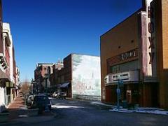
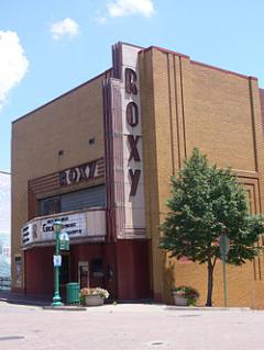
In recent decades, the size of Clarksville has doubled. Communities such as New Providence and Saint Bethlehem were annexed into the city, adding to the overall population. The creation of Interstate 24 north of Saint Bethlehem made the area prime for development, and today much of the growth along U.S. Highway 79 is commercial retail. In 1954, the Clarksville Memorial Hospital was founded along Madison Street. Downtown, the Lillian was renamed the Roxy Theater, and today it still hosts plays and performances weekly. Clarksville is currently one of the fastest growing large cities in Tennessee. At its present rate of growth, the city is on track to replace Chattanooga as the fourth largest city in Tennessee by 2020.
The Roxy has been used as a backdrop for numerous photo shoots, films, documentaries, music videos and television commercials; most notably for Sheryl Crow's Grammy-award winning song All I Wanna Do, which was shot in front of the Roxy in downtown Clarksville.
The Monkees 1966 classic #1 song Last Train to Clarksville was supposedly inspired by the city's train depot and about a soldier from Fort Campbell during the Vietnam War era, wanting to see his girlfriend one more time before deployment, fearing he may never come back home. Fort Campbell was also the Home of Jimi Hendrix when he was a member of the 101th[clarification needed] Airborne Division in 1962. Parts of Clarksville are also briefly seen in the songs Music video.
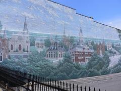
On the morning of January 22, 1999, the downtown area of Clarksville was devastated by an F3 tornado, damaging many buildings including the county courthouse. The tornado, 880 yards (800 m) wide, continued on a 4.3-mile (6.9 km)-long path that took it up to Saint Bethlehem. No one was seriously injured or killed in the destruction. Clarksville has since recovered, and has rebuilt much of the damage as a symbol of the city's resilience. Where one building on Franklin Street once stood has been replaced with a large mural of the historic buildings of Clarksville on the side of one that remained.
On Sunday, May 2, 2010 Clarksville and a majority of central Tennessee to include Nashville and 22 counties in total, suffered expansive and devastating floods near the levels of the great flood of 1937. Many businesses along Riverside Drive along the Cumberland River were totally lost.
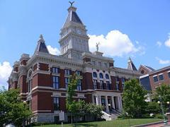
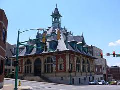
The first Montgomery County courthouse was built from logs in 1796 by James Adams. It sat close to the riverbank on the corner of what is now present-day Riverside Drive and Washington Street. It was later replaced by a second courthouse built in 1805, and a third in 1806, with the land provided by Henry Small. The fourth courthouse was built in 1811, and the first to be built of brick. It was constructed on the east half of Public Square, with the land donated by Martin Armstrong. In 1843, yet another courthouse was built, this time on Franklin Street. It would remain standing until the Great Fire of 1878.
The sixth and current courthouse was built between Second and Third Streets, with the cornerstone laid on May 16, 1879. This particular building was designed by George W. Bunting of Indianapolis, Indiana. Five years later, the downtown area was hit by a tornado, which damaged the roof of the courthouse. The building was rebuilt. On March 12, 1900, the building was again ravaged by fire, with the upper floors gutted and the clock tower destroyed. Many citizens wanted the courthouse torn down and replaced with a safer one, but the judge refused and repaired the damage.
The courthouse was destroyed once again by the January 22, 1999 tornado. The building of another new courthouse was on the minds of locals, but in the end the courthouse was fully restored as a county office building. On the fourth anniversary of the disaster the courthouse was rededicated. In addition to the restoration of the original courthouse and plazas, a new courts center was built on its north side.
The following notable people were born in or have lived in Clarksville:
Clarksville Academy
The Clarksville-Montgomery County School System operates a total of 36 public schools to serve about 30,000 students, including seven high schools, seven middle schools, 20 elementary schools, one magnet school for K-5, and the Middle College @ Austin Peay State University.
Public high schools (grades 9-12) in Clarksville-Montgomery County:
Public elementary schools in Clarksville-Montgomery County:
Biggest public primary/middle schools in Clarksville-Montgomery County:
Private high schools in Clarksville-Montgomery County:
Private primary/middle schools in Clarksville:
Major industrial employers in Clarksville include:
Other notable local companies include:
Clarksville is served commercially by Nashville International Airport but also has a small airport, Outlaw Field, located 10 miles (16 km) north of downtown. Outlaw Field accommodates nearly 40,000 private and corporate flights a year, and is also home to a pilot training school and a few small aircraft companies. It has two asphalt runways, one 6,000 feet (1800 m) by 100 feet (30 m) and the other 4,004 feet (1200 m) by 100 feet (30 m). Outlaw Field has received a $35,000 grant. The terminal is under renovation.
Cobb Field is a small private Airport. It is 3 miles (4.8 km) west of the Dover crossings area. just across the street from Liberty elementary. It has 1 runway grass/sod runway that measures at 1,752 ft (534 m). This airport is not open to the public.
In the June 2004 issue of Money, Clarksville was listed as one of the top five cities with a population of under 250,000 that would attract creative class jobs over the next 10 years.

Word Count: 4821